It seems my new fall tradition is to take a solo road trip and remind myself what it’s like to drive a car! Last fall I explored New Mexico, and this October I found myself winding my way through California’s curviest roads as I traveled Highway 1 from SF to SLO, Tioga Road in Yosemite National Park, King’s Canyon Scenic Byway in King’s Canyon National Park and General’s Highway in Sequoia National Park.
I took turns between being terrified of plunging to my death, in awe of my beautiful natural surroundings, and slightly dizzy/queasy.
Here’s how it went down:
Day 1: Highway 1 from SF to SLO
miles driven: 266
TUNES & PODCASTS: MAINLY A PERSONAL PLAYLIST WITH A LOT OF TAYLOR SWIFT & NOAH KAHAN ON REPEAT
I had a very early flight out of JFK - so there was no way I was going to take the subway at 5 am. Instead, I coughed up the money for a Lyft while giving myself my usual justification - “your Lyft account is linked to your SkyMiles account so you’re basically just paying yourself for a future flight…” (If you fly Delta, link your Lyft account! You earn miles for every ride & double miles when your ride is to and from the airport!)
The flight went swimmingly - I slept, I listened to a podcast, and I watched the Marcel the Shell with Shoes On movie and I’m not going to say that I cried but…
Getting from the terminal to the Rental Car Center at SFO was pretty simple - just hopped on the AirTrain and rode it a few stops.
I rented through National, and since I have an account, it’s one of those situations where you just walk out, pick a car you like, and drive off into the sunset. It always feels wrong somehow, like there needs to be some step that I’m missing?
stop #1: soul grind coffee, pacifca
I had been warned to make sure I stayed caffeinated on my drive - since I would be driving Highway 1 North to South and be in the outside lane - with not much separating me from plunging off a cliff. My white Toyota Camry and I headed to Soul Grind in Pacifica, a super cute coffee shop full of way-too-cool looking people. Instead of stopping throughout the day for multiple coffees I decided to just go big from the start and ordered a cold brew with two shots of espresso.
“It’s that kind of morning, huh?” asked the barista.
“I just flew in from NY so I’ve been up for a long time already!” I replied.
“Where in New York do you live?” she asked as a follow up…hold up, a follow up question?
There’s something very disorienting about being outside of New York when people speak to you and you realize they’re totally open to having an actual conversation instead of asking a question to be polite but not actually caring about your response.
I continued on, rocket fuel in hand (it very much tasted like rocket fuel, too. It was not enjoyable and I do not recommend my order to anyone looking to actually enjoy the taste of their beverage. But hey, it kept me awake!)
Stop #2: bunker point
The goal in stopping at Bunker Point was to get a cool photo - but it was still 11:30 am and the SF fog was thicccc. I called this one a loss, and journeyed on.
stop #3: martin’s beach
When I put this on my itinerary, I wasn’t aware of the drama surrounding it! But there was still a ton of fog AND a fee to park here so, I skipped it!
stop #4: shark fin cove
By this point the fog was lifting but it was pretty gray out. I still took the opportunity to stretch my legs and walk down to this shark-fin shaped rock and take some pictures. The tide was right, and I was able to go into and explore one of the caves.
To navigate here - put “Shark Fin Cove Parking Lot” into Google Maps. Walk south to the end of the parking lot, cross the train tracks and take the steep trail down to the beach.
stop #5: monetery, lover’s point park
In an ideal world, where I wasn’t trying to mitigate hip pain, I had planned to run the Monterey Bay Coastal Trail for five or so miles from Lover’s Point Park to Fisherman’s Wharf.
A run wasn’t in the cards, so instead I walked a bit along the water to laugh at the elephant seals before grabbing a late lunch (it was 2:30 by this point) at Lover’s Point Beach Cafe. I will give you one guess as to what I ordered.
Yes, the turkey panini.
stop #6: big sur
Originally, I had planned on turning inland when I hit Monterey, and taking the 101 to San Luis Obispo because I was nervous to be driving through Big Sur after dark. Plus, what was the point if I couldn’t see anything? But since Bunker Point and Martin’s Beach had been kind of a bust - I was ahead of schedule and had plenty of time to continue on California 1!
Finally, the skies were blue and the journey from Monterey to SLO was absolutely stunning. I didn’t stop tooo much (because of a wrong turn that got me trapped in Pebble Beach for 45 minutes) but there were a few viewpoints that I simply couldn’t pass up. This one is from the Julia Pfeiffer Burns State Park Vista Point.
I understand now why things like the view of Bixby Bridge are so iconic (but driving over it was mildly terrifying).
I loved this part of the drive, and the timing worked out perfectly. By the time I got to San Simeon Bay the sun was setting and I wasn’t far from my destination: dinner with my friends’ family to kick off their wedding weekend!
DAY 1 COSTS:
Lyft to the Airport: $78.75
Curbside Luggage Tip: $5
Rental Car: $53.36
Coffee at Soul Grind: $6.60
Lunch in Monterey: $16.33
Total: $160.05
I packed my breakfast for the flight (after having too many yogurts taken away at security, I fly with overnight oats now!), dinner with my friends’ family (and dessert!), and stayed with my friend for the night at her mom’s (absolutely stunning) house. So those things were all free 99!
Days 2 & 3: Wedding Weekend in SLO
Such a happy and wonderful weekend celebrating my friend! From the rehearsal dinner and welcome drinks, to getting ready together the morning of the wedding and dancing the night away in the perfect California weather - it was perfect! I will not stop talking about how delicious the food was and how wonderful family-style dining is at a wedding!
DAY 2 & 3 COSTS:
Rental Car: $106.72
I was able to use hotel points, which was great (thanks, Marriott!) and enjoyed their free breakfast and food at the wedding-related events on Friday and Saturday.
Day 4: SLO to Yosemite!
miles driven: 234
miles hiked: 6.5
TUNES & PODCASTS: my ‘places’ playlist - only songs whose titles are places!
Trails: Mariposa Trail of Giant Sequoias (alltrails link)
I was up and out early on Sunday morning to start my journey to Yosemite. Let me tell you - waking up without a hangover the morning after a wedding is a real life-hack.
My first stop was the gas station on the corner - which I mention for two reasons. 1) I grew up in a small town where the gas station closest to my house pumped the gas for me. I’ve probably pumped my own gas less than 20 times at the age of 32. 2) WOW the gas prices in California are crazy! My friend passed one gas station near Big Sur with prices in the $9 range!
After that I drove to 3+ hours to Oakhurst, where I stopped at a Von’s for a (duh) turkey sandwich and to grocery shop. I didn’t have a cooler with me, but I picked up some reliable hiking go-tos: rice cakes, peanut butter, bananas, apples, avocado, tuna packets, pretzels, dried mango, oatmeal cups, pepperoni, protein bars, cans of Celsius and Yerba Matte incase coffee was hard to get, and Tate’s chocolate chip cookies.
From there it was another 35 minutes to the Wawona Road entrance to Yosemite - where I purchased my America the Beautiful pass for $80 - good at any National Park for the next year! (Otherwise, it’s $35 for Yosemite-specific pass that’s good for 7 days. Knowing I would also be paying to enter King’s Canyon & Sequoia National Park (also $35) in made sense to buy the annual parks pass in the hopes that I make it to at least another park by next October!
mariposa grove
Right beyond the Wawona gates was the parking lot for Mariposa Grove. I didn’t realize there would be a shuttle bus involved, but it was only a 5 minute wait before the next bus pulled up to bring us to the trailhead. I used the quick 10 minute drive to eat half of my Von’s turkey sandwich.
The trail starts off pretty crowded with people looking at the first few famous sequoias - first you’ll find the Grizzly Giant - the widest tree in the park - followed closely by the California Tunnel Tree.
After that, the trail was pretty empty - and honesty not my favorite as it takes you on what feels like a service road as opposed to a trail. It would have been great had I been able to run, though! I really liked the Clothespin Tree and the view from Wawona Point made me feel like there was some payoff!
As I finished the trail I saw a shuttle pulling up and justttt made it on, which was great, because the shuttles only run every 20 minutes or so.
If you’re just going to Yosemite - it’s definitely worth it to spend some time with these fascinatingly old and giant trees. But if you plan on going to Sequoia before or after Yosemite - I would say you can skip Mariposa Grove (sorry, Grizzly Giant).
tunnel view
On my way from Mariposa Grove to check-in at my Curry Village canvas tent (a little over an hour away) there were a few drops of rain and then I realized a double rainbow was appearing! I passed Tunnel View lookout point at just the right time, and turned in despite the chaos of cars who had the same idea. I waited very impatiently for a spot to park so I could jump out and snap a few pictures. What a welcome!
Rainbow aside - the view from here absolutely took my breath away. Pictures do not do it justice, but I’ll post some anyway. At this point, I was incredibly excited for the next two days.
curry village
I had somehow scored a reservation at Curry Village, one of the lodging options that’s actually in Yosemite National Park.
I reserved an unheated canvas tent for three nights, and I made it to check in just before sunset when I could still see where I was going and get the lay of the land.
I absolutely loved this place. It was way bigger than I thought - the property has 60 cabins and 403 canvas tents!
I did a little walk around, ate the second half of my giant Von’s turkey sandwich, and got into bed early with anticipation for my first full day in Yosemite.
STAYING AT YOSEMITE’S CURRY VILLAGE:
Front Desk
This is open 24/7 which is great for people looking to check in or out during off hours. It’s also the only place on the property that you can connect to WiFi, so you’ll find some people standing and sitting around the front desk with their laptops trying to get out an email. Don’t expect to be streaming anything with this WiFi…I actually had pockets of cell service at random spots around the property. But the best time to get texts out was at the summit of my hikes - so, a little extra motivation! Hike to the top of the mountain, and you can let your family know your alive or your let you Instagram followers see the view.
Guest Lounge
The guest lounge was open from 7 AM - 10 PM daily (all of the hours vary throughout the season, so this only applies to the fall!). It had some comfy furniture, additional tables to eat at, Fooseball, pool, etc. It was actually way quieter in there than I expected. Most people were respectful and most of the kids were busy running around outside (there were a LOT of loud kids. I hate to be that person to complain about kids but…it has to be said!) The Guest Lounge also had TONS of outlets - which is great for people like me staying in the unheated tents without power. The guest lounge also had comfy rocking chairs which was a great place to sit with a crossword puzzle while I waited for my pizza one night.
Coffee Corner
Curry Village is like heaven for hikers - so I should have known that they would have a place to get coffee and giant cinnamon buns at 6:30 am every morning. And believe me, there was a line-up by 6:20! There were also some grab and go yogurt parfaits, oatmeal cups, egg sandwiches, etc. The coffee shop closed at 11 am each morning - but if you’re looking for an afternoon caffeine boost I believe the Pizza Deck serves coffee as well when they open at 12 pm! (In the summer, this is where you can get ice cream, too!)
Dining Pavilion (Seven Tents Pavilion)
The dining pavilion was definitely a bit of a let down - it sounds like they’ve struggled to staff it, which explains the limited options. From what I saw, they served breakfast from 7 AM - 10 AM (pretty basic offerings - hard boiled eggs, hot eggs, bacon, pancakes). They also serve Grab & Go lunch food from 11 AM - 3 PM which I was never around for.
Pizza Deck
This is the place to be every night in Curry Village! Pizza Deck serves small, medium and large pizzas as well as slices (but if you’re a solo traveler like me, skip the slice and go for the small pie!) as well as pre-packaged basic salads. Open from 12 PM - 9 PM, be aware that this is pretty much what everyone is going to be doing for dinner - so you can expect to wait around 45 minutes after you place your order to have the pizza in your hands.
Bar 1899
The bar is open from 12 PM - 9 PM and along with serving beer, wine, cocktails, etc. they have a small food menu with things like wings, artichoke dip and tator tots. My biggest regret is not realizing that they had a non-alcoholic beer on the menu!!
Gift & Grocery
8 AM - 8 PM (I thought that for the off season, all of the hours of the various outlets were very generous and reasonable!) This place really has most of what you could need - and the prices weren’t exorbitant either. They didn’t have a ton of sizes for their apparel, and a few of the shelves were bare by Tuesday, but one night I was able to pick up a pre-packaged salad, sandwich, avocado and tomato for dinner. They also have beer, wine, fire supplies, and all of the normal souvenirs.
Mountain Shop
8 AM - 8 PM. This is the place to stop if you, like me, forget your water bladder. Again - it was a pleasant surprise to see that they hadn’t marked everything up (a one liter Platypus only cost me $10). The focus of the store is definitely on climbing gear - but they had some really nice Patagonia, Prana, North Face, etc. apparel.
Bike Rentals
Had I had more time, I would have loved to do a half day bike rental and cruised around the Valley! I would definitely recommend it if you or someone you’re with don’t love hiking. The Valley is flat and safe for biking and it’s easy when you can rent right from Curry Village (open 9 AM - 5 PM).
Meadow Grill
Closed for the season.
Swimming Pool
Closed for the season.
Shower Houses
There are three shower houses on property - I used the “Pool” Shower House and never had any issues, waited on any lines, etc. It wasn’t a far or inconvenient walk at all. Just show your room key, pick up a towel, and voila. They’re closed for cleaning twice a day at various times depending on the location.
Pro-Tips:
Bring a lantern, flashlight, headlamp…something to use when you’re eating dinner at night. While there are plenty of picnic tables around the pizza deck, there’s no lighting! If you don’t feel like eating in the dark, you can go into the Guest Lounge which is well lit and has tables.
If you tired of pizza for dinner - The Ahwahnee Hotel, Yosemite Valley Lodge and Yosemite Village are all a quick shuttle ride, car drive or walk away and have their own dining outlets that you’re able to eat at. The Mountain Room at Yosemite Valley Lodge and the Dining Room at The Ahwahnee Hotel both take reservations through Open Table if you’re looking for a nicer meal out. If I’d had more time, I would have loved to check out these other properties.
day 4 costs:
Rental Car - $53.36
Gas Fill-Up #1-$71.18
Grocery Shopping & Lunch at Von’s- $63.65
America the Beautiful Pass - $80
Curry Village Night #1 - $153.22
Curry Village Platypus - $10.82
Total: $432.23
Day 5: Yosemite - 4 Mile Trail
miles driven: 0
miles hiked: 12.4 miles / 3,863 feet
Trails: Four Mile Trail (alltrails link)
I woke up and got myself to the dining pavilion when they opened at 7. I picked up 2 hard boiled eggs and a coffee and then I was on my way to the Four Mile Trailhead. It was about a 2 mile walk from Curry Village to the trailhead, but it made the most sense to walk - the shuttle route would have taken too long since the shuttles only run in one direction.
It was a lovely morning and I stopped for a few pictures of the valley before arriving to start my first big hike!
The Four Mile Trail is actually 4.6 miles one way and 9.2 miles round trip, according to AllTrails. Normally, you can hike up to the viewpoint at Glacier Point and then take the shuttle back down. However, Glacier Road was closed for all of 2022 meaning the only way to the viewpoint and back down is on foot. I actually loved this - it meant that it was so much less crowded. I never like getting to a summit only to find 100s of people that drove up!
You can use the Four Mile Trailhead to start a lot of long routes through this area of the park. Originally, I really wanted to continue on from Glacier Point to the Panorama Trail, passing Illouette Falls, Panorama Point, Clark Point, and the John Muir trail back down to Yosemite Valley. But at 16+ miles, I didn’t want to risk making my aggravated hip too much worse.
The Four Mile Trail up to Glacier Point was fairly easy in terms of terrain. Smooth trail, switchbacks, and my hip wasn’t actively bothering me as I climbed so I powered up this at a pretty quick pace. I passed 23 people, and no one passed me…not that I was counting kills or anything…
The only thing I really stopped for were photo breaks. The views of El Capitan on the switchbacks were incredible, and then you turn a corner and WABAM Half Dome. It took my breath away. At that point you can see Glacier Point and where you’re headed and I also got enough service to text a picture to my parents.
2 hours later, I was at the top, with very few other people, a backpack full of snacks, and all the time in the world. I have never stayed at a summit so long before, but I lounged for an hour like a lizard on a rock. The temperature was perfect, the sun was shining, the visibility was like hitting the lottery.
Eventually I dragged myself away to start the journey down - a task made easier by the fact that I knew I’d still get to see some amazing views as I descended.
I reached the end of the trail the moment a shuttle was pulling up - I jogged and made it in the nick of time! The total mileage came to 12.40 with 3,863 feet of climb in 4 hours and 43 minutes (not counting my hour at the top!)
HIGHLY recommend this hike.
When I got back to Curry Village, I made myself a gourmet meal of avocado and tuna on rice cakes with turkey salami. Then, I grabbed my book and set off in search of a place where I could lay in the sun with my book and journal. I found it in the Lower Pines Campground at an unused campsite where I took over a picnic table for a good 3 hours. It was pure bliss.
Next was a shower and getting cozy before walking back to get a good view of the sunset. One of my favorite things is a communal sunset. Is there anything more wholesome than people gathering to watch the sunset and marvel at nature?? It gives me the warm fuzzies.
After that, I put in my order for pizza! I went in expecting to have to order two slices since I was solo but they had personal sized pies! Or at least, I made the “small” a personal-sized pie!
I sat on a rocking chair outside the guest lodge and read with a Diet Coke while I waited about 45 minutes for my pizza to be ready. It was good, not great, but I think I might have mis-ordered. I should have gone with the El Capitan. Next time!
Then it was bed time! I feel like half the trip I was packing and repacking bags, organizing what I needed the next day, figuring out what needed to go into the bear locker so I wouldn’t get eaten, etc. Going to bed I had everything laid out that I would need for a full day of hiking the next day.
day 5 costs:
Rental Car - $53.36
Breakfast - $7
Curry Village Night #2 - $153.22
Dinner from Pizza Deck: $15.50
Total: $229.09
Day 6: Yosemite - Cloud’s Rest
miles driven: 100
miles hiked: 12.5 miles / 2,926 FT
Trails: CLOUD’S REST (alltrails link)
Another morning rising with the sun!
Originally, my plan had been entering the lottery for the Half Dome hike -you need a permit and I was in Yosemite for the last two days where the cables are in place for hikers. But, with my hip acting up, I didn’t want to chance the 15 mile, 5,000+ feet hike and instead, settled for what I had heard rave reviews about: the Cloud’s Rest trail!
I was a little nervous that this trail was an hour and 15 minutes away from Curry Village along Tioga Road, but knew it was pretty popular and I’d likely encounter other people on the trail.
I joined the line of early risers waiting for the coffee shop to open and at 6:38 (people were not too pleased about the 8 minute delay) got myself a yogurt parfait and iced coffee and headed on my way.
There’s something about starting the day as the sun rises, driving through winding curvy roads, listening to music that makes you want to slap the steering wheel, that cannot be beat. In fact, this entire day was essentially the perfect day from start to finish.
At the trail head there were a few other people which calmed my nerves. I put the food I planned on eating post-hike into the communal bear lockers, went to the bathroom, and did my best to get a head start on the giant group of high schoolers about to set out.
On the one hand, I loved that such a large group was going to be on the trail - complete with chaperones who I assumed were qualified in some way to be leading the trip. On the other hand, I did NOT want to be trapped in this group for the entire 12 mile hike.
Luckily, they let me scamper away and ultimately I think I ended up being ahead of the group by like 90 minutes.
Cloud’s Rest starts mellow and then there is a long, steep, slog up rocks that gave me some PTSD to the Presidential Traverse. You climb 1,000 feet in around a mile of rocky switchbacks. I was just starting to wonder if I was destined to climb up rocks the entire time when it leveled off, went down a bit, and was flat again for quite awhile! The mellow miles went through pretty woods and passed by a pond and I enjoyed being beneath the tree line for awhile. The next section of incline was way smoother and wider trails until the final ascent to Cloud’s Rest which was another rock climbing adventure and may not be the best for anyone scared of heights. It’s very exposed with drop offs galore.
From a review of the trail I read online:
Elevation-wise, Clouds Rest is a four-part trail shaped like a staircase, albeit one built by a contractor who was paid in tequila. Part one is a gentle, nearly flat walk of just under two miles through the Tenaya Lake valley. Part two is a tortuous series of switchbacks covering a thousand feet of elevation gain in a mile, leading at the summit to the Sunrise Lakes trail fork. After a brief descent, you'll have a leisurely stroll for a few miles through another wooded valley, passing a pretty pond along the way, until you begin climbing Clouds Rest itself. This final section isn't as steep as the first big hill you climbed, but its 9,000+ foot elevation will still take a toll.
-Yosemitehikes.com
The views from Cloud’s Rest were 360 degrees and absolutely stunning. Again, I was blessed with perfect visibility, sun, and barely any wind at almost 10,000 feet. A dream! I settled in for another long-stay at the summit, talking briefly with a guy from Syracuse who agreed with me that parts of this hike were very New Hampshire-esque.
Photos just couldn’t do this justice, but that didn’t stop me from trying. Again - I had a little service at the top which I used to check in with my parents since I knew there had been very little service along Tioga Road.
The return trip felt much quicker, especially knowing how much blissfully flat terrain I was going to get. The steep mile was just as slow going down as it was coming up, but other than that I was back at the parking lot before I knew it.
I then continued a little down the road to a pullout at Tenaya Lake, where I lounged in the sun on a rock yet again and journaled which was bliss.
Back in the valley, I had to sit at the base of El Capitan and just simply marvel at the granite rock face. I was sitting and eating more rice cakes with avocado and tuna when I noticed two couples with binoculars looking at something intently. I realized there were climbers, perched on a ledge. The fact that these two climbers were almost imperceptible to the human eye (and probably would have been invisible were in not for one of them wearing a bright red jacket), put into perspective what Alex Honold had accomplished in his free solo of El Capitan and I just sat there absolutely stunned. I couldn’t fathom it. I still can’t.
Back at Curry Village I showered and did some more reading before heading to the grocery store to pick up dinner. I bought some retro postcards, a sticker for my water bottle which I proceeded to accidentally throw away, a salad, turkey sandwich, avocado, tomato and sparkling water. Ate it all at a dark picnic table and then was ready to crawl into bed.
I was so relieved that I had been able to get these two hikes done, but after 30 miles in 3 days, my hip was really bothering me. I was 100% convinced that it would be back to New York and back on crutches for me, and if there was any hope of staying on my own two feet I knew I would need to seriously cut back on the hiking when I was in Sequoia.
I think the trade off was worth it - I was ok with no long hikes in Sequoia after the Four Mile Trail and Cloud’s Rest - two hikes that I will be remember forever. Those views were like nothing I’ve seen before and the time on my own on the hikes was confidence-building.
I went to bed really really sad about leaving Yosemite.
Day 6 Costs
Breakfast - $14.15
Rental Car - $53.36
Curry Village Night #3 - $153.22
Dinner & Postcards - $26.72
Total: $247.45
Day 7: Yosemite to King’s Canyon & Sequoia
miles driven: 261
MILES HIKED: 2.2
TUNES & PODCASTS: WE CAN DO HARD THINGS WITH REESE WITHERSPOON
tRAILS: General grant trail (alltrails link) and zumwalt meadows walk (alltrails link)
I woke up still really really sad about leaving Yosemite so I made my exit very drawn out. After getting some coffee and checking out, I pulled over somewhere with a great view of El Capitan and ate my oatmeal and drank my coffee while trying to make out Alex Honnold’s “Freerider” route. Legit sat there with a picture of the route mapped out and just stared in disbelief.
After finishing my breakfast and my mental rock climbing, I continued towards the park exit but as I passed Tunnel View Lookout, something prompted me to pull into the parking lot.
I then proceeded to sit for around an hour, watching the sun slowwwwwly rise. It was so calming and I had no service, no headphones in, just me, my coffee and a small crowd of people taking in the simple but stunning scene. This was definitely not part of my initial itinerary for the day, and I knew I was putting myself further behind schedule every minute that I stayed, but I needed to see the sun’s rays emerge before I said good bye to Yosemite.
Once I was satisfied with some big, bright, beautiful sunshine-y rays that appeared all at once, I was back on the road and headed to Sequoia and King’s Canyon National Parks.
It was nice to get in a little bit of highway driving - because the rest of the day would be the windiest roads of my life.
I stopped for another gas refill, and made it to Grant Grove for my first stop around 12:15 PM. These trees are just insane. My favorite part of this stop was reading about the other famously large and old trees around the world. I think it might be a fun travel bucket-list, to visit the top 10 oldest and top 10 tallest trees in the world! Many of the sequoia’s I saw are considered the largest trees in the world - they aren’t necessarily the tallest - but they are the largest by volume with trunks that are 20-30 feet in diameter! (That’s like a stretch limo!)
The rest of the day was spent driving the incredibly windy King’s Canyon Scenic Byway to Zumwalt Meadows. The views were unreal, though they didn’t photograph well. You really have to be there to appreciate it. I felt miniscule compared to the Sierra’s towering above and around me.
After a quick leg stretch at Zumwalt Meadows, I went to the Grizzly Falls picnic area to eat some more rice cakes with tuna and avocado but the yellow jackets were insane, so that was a quick stop.
Originally I had planned on stopping by Buena Vista Peak for a 2 mile hike to watch the sunset, but I knew I needed to rest my hip so I decided to head straight to the hotel.
THANK GOD I didn’t wait until after sunset to head to the town of Three Rivers. For whatever reason, my GPS sent me on the most insane backroad to get there and I honestly almost stop driving just to cry for a little bit. Every turn was a hairpin turn. There was no service. I was in the middle of nowhere. And I was tired and cranky. Not a good mix. I told myself that if this was the way I had to go back to the park in the morning, I simply was not going to do it.
But I finally made it to Sierra Lodge, a pretty shitty little motel that smelled overwhelmingly of dollar-store brand cleaning products. But hey, it was close to the park, Three River’s was actually a cute little town, and it was cheap!
I dropped off my stuff and headed to the center of town (it’s essentially one road) to the grocery store where I picked up some more food and snacks then went next door to the Mexican restaurant. I was pleasantly surprised to see that they had O’Doul’s on the menu - a non-alcoholic beer really hit the spot with my chips and salsa and tacos! I was in heaven sitting outside (it was SO hot in Three River’s!), journaling and eating.
Day 7 costs
Morning Coffee - $3.27
Gas Fill #2 - $58.61
Rest Stop Seltzer - $1.84
Rental Car - $53.36
Sierra Lodge Night 1 - $98.40
Three Rivers Grocery: $20
Casa Mendoza Dinner - $27.89
Total: $263.37
Day 8: Sequoia National Park
miles driven: 76
miles hiked: 6
tRAILS: Moro rock via grant forest museum (alltrails link) and CONGRESS TRAIL (alltrails link)
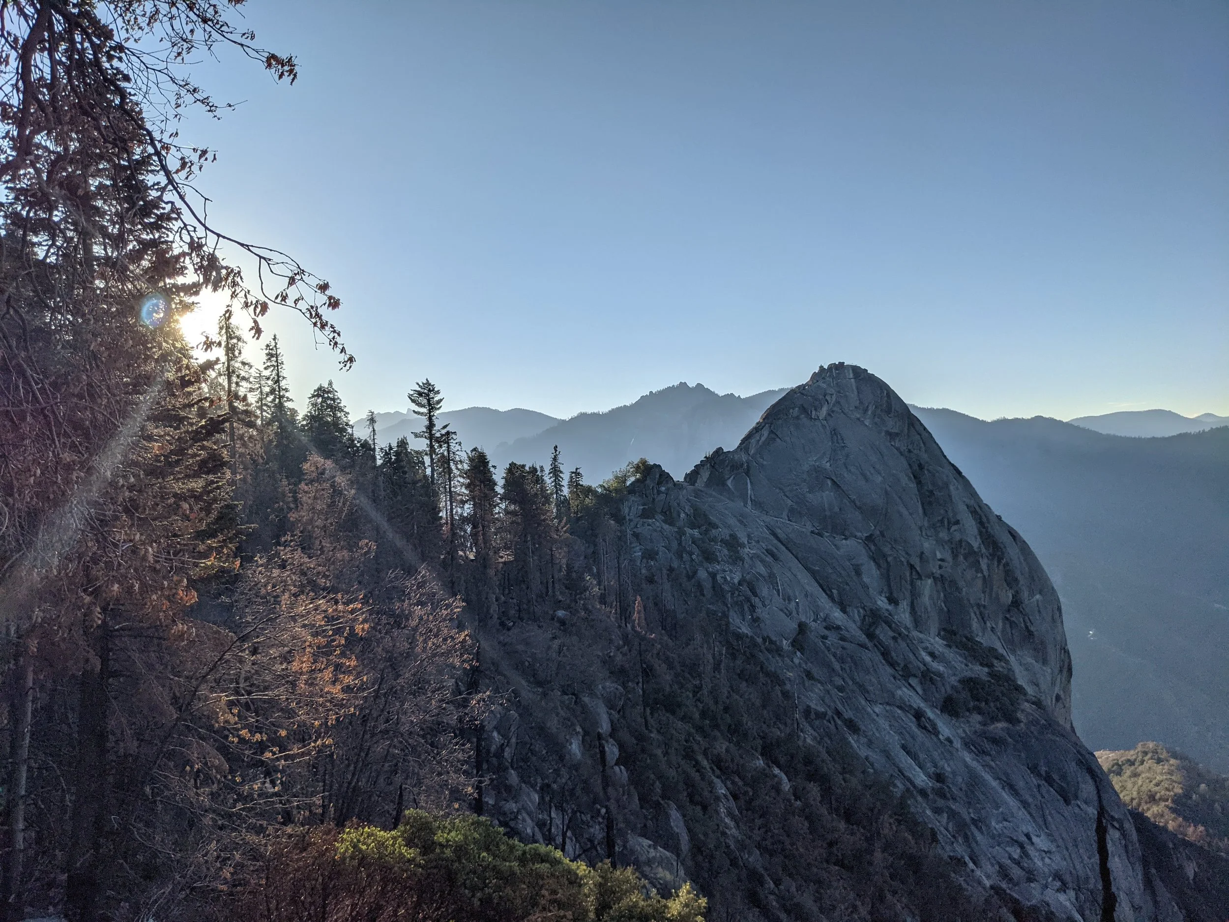
sunrise at moro rock
Day 8’s mission was to catch the sunrise at Moro Rock, so I was up and out in the pitch black, headed back to Sequoia. Luckily, I didn’t have to take the same road as Day 7, but that didn’t mean it was a straight shot to the trailhead. Far from it! The 20 mile drive along General’s Highway to the Grant Forest Museum was still incredibly curvy and needless to say, there are no streetlights in National Parks!
I was one of only two cars in the parking lot when I arrived and donned my headlamp. For the most part I felt brave on my dark hike - mainly because I knew that the trail ran alongside the road. Eventually, the sky started brightening which put some pep in my step…I was not going to wake up this early and then miss the sunrise!
When I arrived at Moro Rock I realized I could have driven my car right to the base of it …oops! The climb up the rock itself was longer than I thought - around 350 stairs! There were about 8 other people up there and I sat down and was treated to a beautiful sunrise.
On the walk back to the museum I stopped for a photo at hanging rock and I also really enjoyed being around the massive sequoia’s in more a natural feeling way as opposed to the Congress Loop which I would go to later in the day that’s got more infrastructure in terms of trails and printed information.
congress loop
Next up was the Congress Loop, which is a 3 mile loop trail that brings you by General Sherman - the largest tree by volume in the WORLD.
This is one of the most popular trails in the park, and while there were certainly a decent amount of people there, it was by no means crowded. I learned a ton from the printed signs along the trail and they did a good job with some interesting ways of trying to put the true size of General Sherman into perspective.
I also learned that fires in 2020-2021 killed 13%-19% of the world’s sequoia trees! But at the same time, fires are a huge part of their survival and growth.
Tunnel tree
After visiting General Sherman, my rental car and I took a trip through the Tunnel Tree which I was shocked to find with zero line and next to no one around! I assumed there would have been a line of cars! While I took a moment to appreciate the tree itself - I also took some time to pat myself on the back for a LOT of driving on this trip, something that I am admittedly not the most comfortable with!
General grant forest museum
I hadn’t planned on making a visit to the General Grant Forest Museum because it just seemed a little lame, but after the Congress Loop I was really interested in learning more so I’m glad I took the time to go through it (and buy myself a Christmas ornament).
One fun fact: it would take more than ten blue whales to balance the weight of the trunk of a sequoia alone!
Wuksachi lodge
The only lodge that was open at this point in the season was the Wuksachi Lodge so I headed there next for some coffee and lunch. It had turned out to be an absolutely beautiful, sunny day and I sat out on the balcony with a book for a longggg time (like 3 hours)! Along with a chicken/veggie sandwich that was chef’s kiss!
When I felt that I had started to outstay my welcome, I got in the car to head back to Three Rivers and treated myself to some froyo. Can we talk about how cute this froyo place is?
The difference in temperature between the park and Three Rivers was INSANE. When I got back, it was in the 90s! I stopped at a few souvenir stores - the one shaped like a dome was super cute but I can’t find it online!
That night I ate the other half of my chicken sandwich and a pre-made salad from the market out on my balcony while watching some bad reality TV on my phone, trying to ward off the sadness that my time in nature had come to a close.
DAY 8 COSTS:
Sequoia National Park - $23
Three Rivers FroYo - $5.95
Dome Souvenirs - $14.01
Wuksachi Dining - $3.76 (Coffee)
Wuksachi Dining - $23.97 (Lunch)
Rental Car - $53.36
Sierra Lodge Night 1 - $98.40
Total: $222.45
Day 9: Sunnyvale & SFO
miles driven: 270
TUNES & PODCASTS: NOAH KAHAN STICK SEASON!! (RELEASE DAY!)
Before getting back on the road I stopped for coffee at the cute roadside Sequoia Coffee Co. Great menu!
From there, I headed to Sunnyvale, a town in Silicon Valley where I could kill some time before my red-eye. I wish I had found a better way to spend this day. Ideally, I would have gotten in another hike, or a trail run - but we were in full-on hip preservation mode at this point so sitting was the name of the game.
I hung out in a coffee shop, wandered around a book store, and picked up dinner at Dish N Dash before dropping off my rental car and making my way to the airport.
Next stop? The SFO yoga room where I did a full on Peloton yoga class before my flight. It was amazing! Should be mandatory at every airport.
Day 9
Sequoia Coffee Co. $3.25
Coffee & More - $3.84
Dish N Dash - $16.64
Taxi Back to Apartment $66
Oct. 12 Coffee $3.27
Last Gas - $72.72
Rental Car - $53.36
Total: $219.08
Final Thoughts
This was my second solo trip, and just like my New Mexico trip, it was magic. I did a lot of thinking on the many hours of driving, and I felt capable and confident.
It always surprises me how totally fine I am being alone for days on end - if I ever again wonder if I’m an introvert or an extrovert, I will think of this trip and remember trees > people.
The only thing that would have made this trip better would have been if I didn’t have this giant black cloud hanging over my head - being convinced that I had a stress reaction in my right hip. The day after I landed back in New York, I was back on crutches, in for an MRI and awaiting the results. Miraculously, a few days later I found out that it was clear, and the diagnosis was hip impingement. I was so relieved, and so glad that I had decided to go through with the trip. Would I have hiked even more miles had my hip felt OK? Yes. But overall, the trip was still incredible.
Yosemite is LIFE CHANGING. I can’t get over it. Magic.
Traveling alone has one main drawback - you aren’t splitting the costs with anyone else. While I don’t usually do budgeting recaps on my blog posts, I was interested to see what this trip ended up costing. The grand total for a 9 day solo California road trip? $1,880.44. That sounds like a lot of money, but when you think about it as an average cost of $208.94 per day, I think it’s a lot more reasonable for a bucket list trip.
I dove 1,207+ miles! I definitely feel like I’m more comfortable driving without having anyone else in the car.
Let me know if you have any questions or comments!
YOU MAY ALSO LIKE:


